Perhaps The Climate Change Models Are WrongWhen the facts don't add up, you improvise. The Argo buoys, instead of finding the global warming as the computer models have predicted have found a slight cooling of the worlds oceans. This is dismissed as an 'anomoly' and not important. I ask a simple question, if the Argo buoys had detected a slight warming, would it be an 'anomoly' and not important? You know the answer, don't you?
They drift along in the worlds' oceans at a depth of 2,000 metres -- more than a mile deep -- constantly monitoring the temperature, salinity, pressure and velocity of the upper oceans.
Then, about once every 10 days, a bladder on the outside of these buoys inflates and raises them slowly to the surface gathering data about each strata of seawater they pass through. After an upward journey of nearly six hours, the Argo monitors bob on the waves while an onboard transmitter sends their information to a satellite that in turn retransmits it to several land-based research computers where it may be accessed by anyone who wishes to see it.
These 3,000 yellow sentinels --about the size and shape of a large fence post -- free-float the world's oceans, season in and season out, surfacing between 30 and 40 times a year, disgorging their findings, then submerging again for another fact-finding voyage.
It is important, it means the global climate models(GCMs) have the sign wrong, more specifically as has been pointed out by many, the effects of clouds ... the GCMs are all in error when trying to predict the future. I have a simple test, easy to perform, takes just computer time. Initialize the GCMs for the year 1979, using the conditions that existed -- And then run the computer models and predict the year 2007. That should settle it. Why start with 1979, simple, it's the first year that reliable monitoring data is available, satellite data.
Back to ARGO ...
Argo is a global array of 3,000 free-drifting profiling floats that measures the temperature and salinity of the upper 2000 m of the ocean. This allows, for the first time, continuous monitoring of the temperature, salinity, and velocity of the upper ocean, with all data being relayed and made publicly available within hours after collection." - from the Argo website. In Greek mythology, Jason sailed on the ship Argo to capture a golden fleece. In the world of oceanography, Jason is a satellite altimeter that allows scientists to measure the heights of the ocean surfaces. This worldwide buoy program was named Argo because the data from the Jason project and from this buoy project will be used together in computer models to help forecast ocean climate.
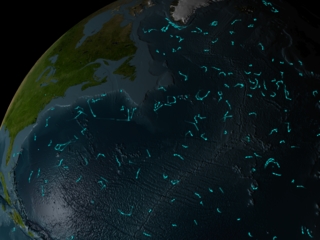
This visualization shows the locations of the ARGO buoy array over time. When the bouys are above water, the lines are brighter; when the buoys are under water, the lines are fainter. The ARGO buoys measure ocean salinity, column temperature, and current velocities.
 | Animation showing locations of the ARGO buoy array Duration: 1.6 minutes Available formats: 320x240 (30 fps) MPEG-1 13 MB 640x480 (30 fps) MPEG-1 52 MB 720x480 (29.97 fps) MPEG-2 84 MB 320 x 240 JPEG 48 KB 720x486 (30 fps) Frames How to play our movies | |
| | ||
 | ARGO buoys over the northern Atlantic Available formats: 2560 x 1920 TIFF 6 MB 320 x 240 JPEG 53 KB 80 x 40 PNG 5 KB 160 x 80 PNG 19 KB |
ARGO website has some fascinating animation tools and lots of images of buoys and plots.
2 comments:
WTF?
Is it getting warmer or colder then?
Duh, either the collected data or the hypothesis of global warming is wrong. All 3000 buoys must have a glitch! It's so obvious.
Post a Comment